This week I was given permission to transcribe a radio interview from the weekly show, "The Book & the Spade" (broadcast archive #1073)...
*******
Gordon Govier (GG): We're talking about the Babylonian Exile. In fact our interview today is based on a presentation called "The Babylonian Exile Decoded: An Archeologist Searches for Clues", & our guest is Jeffrey Zorn, professor at Cornell University. This involves a site called Tell en-Nasbeh, which is probably Biblical Mizpah, located just north of Jerusalem. Jeffrey, the identification of Tell en-Nasbeh as Mizpah is pretty strong?
Jeff Zorn (JZ): Yes, it's really very strong. There's only 1 other site in the area--a place called Nebi Samwil, which people back in the early 20th century considered as a possible candidate, but excavations at Nebi Samwil haven't really found archeological materials that correspond with what we know about Biblical Mizpah, whereas Tell en-Nasbeh's material cultural remains really match very well with what we know about Mizpah.
GG: It's a site that our listeners may recognize as associated with the prophet Samuel, but also became very important after the Babylonians conquered Jerusalem.
JZ: Yes, when the Babylonians conquered Jerusalem, they of course had to take some thought for how they were going to administer the area. They pretty well devastated most of the kingdom of Judah, but during their year & a half long siege of Jerusalem, they seemed to have left the area of the tribe of Benjamin (which is to the north of Jerusalem & part of the kingdom of Judah) untouched. They would've used it as a base of resources. Instead of having to bring their supplies all the way from Assyria, they could just get it from the hinterland of Jerusalem itself. Mizpah would've been left untouched, so it would've made a very convenient administrative center once Jerusalem was destroyed.
GG: They were probably more familiar with that site than anywhere else in the neighborhood based on their siege.
JZ: Oh yes, Benjamin's not a very big area, 10 miles deep, I guess you could say, & 30 miles wide. So it's not a big area & Mizpah would've definitely been the most prominent site in the area. It had been fortified in the early 9th century by King Asa of Judah & was really the major border fortress against any sort of invasion coming from the north.
GG: And the archeology that was done there is confined mostly to the early 20th century.
JZ: Yes, the site was excavated by William Frederic Bade of Pacific School of Religion in Berkeley, California between 1926 & 1935 in 5 excavation seasons. And they actually uncovered about 70% of the site.
GG: So what does it look like today?
JZ: Well if you went there today, you'd see a very nice refrigerator graveyard. The tell itself is completely covered over. It's privately owned land. Bade had to agree to bury everything again once he was done with his excavations. So you can't see anything there, but that means that it's all well preserved under the ground, & it could be dug up again at any time.
GG: Is it in an urban area now?
JZ: Ramallah is just to the north of the site, & there's gradual creep of houses down around the site, but it's still pretty open. The tricky part, of course, is once the state of Israel was established in '48, Tell en-Nasbeh was in The West Bank, & so it was a sort of tricky area to excavate then or to visit then. And then from '67 on, that area's been under Israeli control, & of course since the 1990s the area's become under increasingly Palestinian control. And until very, very recently the border between the Jerusalem municipality under Israeli control, & the Palestinian territories went across Tell en-Nasbeh. In the last few years they've moved the border south, & so now Tell en-Nasbeh is completely in the Palestinian-administered areas.
GG: Well that doesn't sound too much different than what it was like during the Biblical period.
JZ: No, it was a border site then & it's a border site now. And of course they make it very difficult to go & excavate. Not too many people wanna go on the border between the Palestinians & the Israelis right now.
GG: If it wasn't for the political situation, would you give some consideration to going there?
JZ: Oh I'd be there in a second if there were no political preconditions.
GG: You worked on this for your PhD.
JZ: Yes, back in the mid-1980s I was a graduate student in Berkeley, & I worked at the Bade Institute of Biblical Archeology, which is part of Pacific School of Religion, & as I got familiar with the Tell en-Nasbeh material, I came to see that it was not really well understood, & thought that a re-analysis of the architecture & stratigraphy of the site could give some new, interesting results.
GG: And this was based on your own work as an archeologist. You worked for a number of years at Tel Dor, I believe.
JZ: Yes, from 1985 until 1999 I was part of the field staff at Tel Dor, & I'm still on the staff of the publication team for one of the areas at the site, & will be going back there this summer. I hope to put the finishing touches on the first draft of material so it can go to the editors.
GG: The Tel Dor excavation has basically changed hands. Ephraim Stern was in charge when you were there, & now there's a new leadership under way?
JZ: Yes, 2 of my colleagues who were graduate students of Stern's (Ilan Sharon of Hebrew University, & Ayelet Gilboa of Haifa University) have taken over the site license, & my old school, UC Berkeley is still at the site. They renewed the excavations after Stern's retirement.
GG: For those who may have just joined us, our guest is Jeffrey Zorn, professor at Cornell University. We're talking about Tell en-Nasbeh, which is probably the Biblical site, Mizpah, & our focus is on the Babylonian period when it was the capital that was established by the Babylonians with inhabitants of Judah taken away into exile. What you found there gives us a different perspective on what was left behind.
JZ: If you read the accounts in the last chapter of the book of 2nd Kings, & some portions of Jeremiah, what you come away with is an impression that the Babylonians tried to depopulate the land of Judah--the Biblical expression is that they left only the poorest of the land, the vinedressers, to be in the area. That gives you the impression that it was pretty well empty, but that wasn't really the case, & there are reasons why the Biblical authors presented this situation as a kind of an empty land. So even though probably somewhere between 50- & 100,000 people might have been living in the land from the perspective of the Biblical editors, it was more convenient to leave them out of the story & speak only of the exiles. And so there would be a tendency not to look for a Babylonian period in the country because, How could you find something when there was nobody there?
GG: What does the evidence at Tell en-Nasbeh indicate? What did you find when you went over the material again?
JZ: Well, Tell en-Nasbeh in the main part of the Iron Age, before 586 & the destruction of Jerusalem, is a pretty typical Judean Hill-Country town. That is the houses are all oriented towards the natural topography of the hill, that is they kind of go in a circular pattern around the site, with a kind of a ring road around the inside of the site to link them up in a couple of crossroads. And the houses are pretty small, about 8 meters long, 6 meters wide, packed one right next to the other, a thousand people crammed into an area a little bit more than 220 meters long & about 120 meters wide. So, small, crowded little farm town, but with big, massive fortifications because of its position on the border. When you get to the Babylonian period, what they did is they went & basically leveled all the houses that were there. If the site had been destroyed in an invasion, you would find materials left on the floor as the people fled & their houses were destroyed. But you don't find that. All you just find are nice, empty rooms that had been completely leveled. And then this leveling created broader, flat surfaces, & then in the Babylonian phase of the site, larger houses & other buildings could be built on top of that earlier Iron Age town. So for example, the houses of the Babylonian phase are at least twice as large as those of the preceding phase. They have more in the way of stone floors. The walls are built of nicer stones. Just all-in-all much bigger, nicer houses than what you had before, & then there are even larger buildings--a structure that I thought might be like a small palace or a residency perhaps for the local administrator, storage structures, & just other little bits & pieces of walls scattered around the site that were definitely not part of the earlier phase, & should belong to this Babylonian period.
GG: So the Babylonians took the elite off to Babylon, but a new elite was created back at Mizpah.
JZ: Correct, they didn't carry off the whole elite. Even if you read the book of Lamentations, which describes the lows experienced by the people after the fall of Jerusalem, you find princes, priests, various members of the elite are mentioned in the book of Lamentations. The Babylonians didn't carry off all the elite; somebody had to be left behind. In fact the prophet Jeremiah himself was left behind in Mizpah with the local Judean administrator, Gedaliah. And we hear also of Judean soldiers who were still there, & people called either the king's "daughters" or "princesses" are left behind. So there's definitely a smaller number of elite segments of society there, but they're definitely there.
GG: When some of the exiles start to come back (we read about in Ezra & Nehemiah), then there was tension between Mizpah & Jerusalem.
JZ: Well, it's hard to say that there's "tension". What we hear about in Ezra & Nehemiah is that there are some local administrators in the area of Judah, & we're talking about in the 5th century now when Ezra & Nehemiah come back, so it's almost a century or so after the initial return from the exile, but we hear about some local administrators including some from Mizpah who take part in the rebuilding of the walls of Jerusalem. So it would've taken a significant period of time for Jerusalem to recover from this devastation & to be rebuilt, so Mizpah probably for some significant period of time after the Jews are allowed to return home would've continued to serve as the local administrative center. Of course we don't have a text that says, "At this point, Jerusalem became a fully-functioning administrative center."
GG: Well you mentioned you'd like to go back to excavate at Mizpah if you had the chance. Is there anything else unresolved that you'd like to do without excavating related to the site?
JZ: Well right now a colleague of mine is doing a very important study on a set of stamp impressions. Stamp impressions are impressions that you would make on jar handles with a seal-like object. And these are called "Yehud impressions" after the name of the Persian province of Judah, which was called Yehud. And he's doing a study of the provenience of the clays that went into these jars in order to see where the jars are being produced, & then where they're being distributed. So that's a really nice example of taking material that's been excavated a long time ago, subjecting it to new scientific tests, & coming up with some new data. I did a similar thing when I looked at jar handles stamped with the word "Mozah". Mosah seems to have been a royal agricultural state that the Babylonians hadn't destroyed, & which during the Babylonian period served as a resource center for Mizpah because most jar handles stamped "Moza" are found at Mizpah. There are still things that you can tease out of the excavated materials without going back & re-excavating the site.
GG: Some new perspectives on the Babylonian Exile period from our guest, Jeffrey Zorn, professor at Cornell University...
*******
I asked Dr. Zorn if his statement about Nasbeh being a "refrigerator graveyard" was hyperbole, but he explained that there really was a pile of about 50 on the northeast corner (which is closest to the access road) the last time he visited the site.
The only thing I would like add to this excellent interview is a brief mention of the major finding that Bade made at Nasbeh, a striated agate seal inscribed "Jaazaniah, servant of the king (LYAZNYEU OBD EMLK)" with a fighting-cock icon. He found it in Tomb 19, & it may have belonged to the army captain mentioned in 2Kings 25:23 & Jeremiah 40:8.
Song of the week: "Borderline" by Madonna (click the song title to visit Amazon; click here for a 23-second sample; 295kb).
G.M. Grena
Saturday, January 27, 2007
Saturday, January 13, 2007
Deep in the TIP (p. 2)
Last summer I reported on the publication of the first in a series of articles by The Society of Israel Philatelists. I am happy to announce Part 2's appearance in the December 2006 issue:
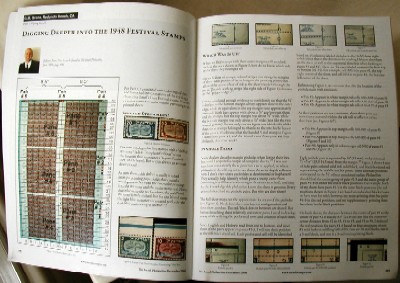
This photo shows the first 2 pages; there's also a 3rd page with only text. Section headings:
"Shifted Streamers?"
"Which Way Is Up?"
"Pinhole Pairs"
Unfortunately, due to some initial chops by the editor & my lack of thoroughness in the final review, there are a couple of errors.
On p. 209, my bulleted description of the locations for Pairs #5 & #6 say, "pane #6" & "panes #1 and #6", respectively. Actually they should be reversed, which should be obvious though from my mentioning of cells G01-I01 & N01, respectively.
Also on p. 209 in the paragraph immediately following the bullets, "...both of my sheets have pairs #1-3 in the same black positions ... my main-printing sheet has pairs #4-6 in the red positions..." is also reversed. In other words, pairs #4-6 are the same on both sheets; my main-printing sheet has pairs #1-3 in the red positions. This, too, should be clear to readers by the detailed description in the subsequent paragraph.
I know it's no big deal, but I like to be thorough, & I like to be correct as often as humanly possible.
Song of the week: "Flying With Broken Wings.mp3" by Angel (click the song title to visit Amazon; click here for a 23-second sample; 295kb).
G.M. Grena
Saturday, January 06, 2007
MMySTery Reigns at Ramat Rahel
[Preface: I originally wrote about 1,200 words in response to the article, "Royal Palace, Royal Portrait?" by Gabriel Barkay in Biblical Archaeology Review vol. 32 #5 (Sep/Oct 2006) & knew it would be too long for inclusion, so I hacked away ruthlessly to present a 500-word version. Still, I knew their space for the Queries & Comments section is limited, so with much weeping & gnashing of teeth, I reduced it to 150 words. Since they chose to print it neither in their Jan/Feb 2007 issue nor on their web page for extra letters, I'm posting all 3 versions here, per chance someone else in the world may find my opinion of interest.]
150-Word Version
Gabriel Barkay says the "first 3 cities are well known from the Bible," but omits the fact that there were 2 Judean cities named Sokoh & 2 named Ziph (Joshua 15).
Similar handles have also surfaced at sites in the northwestern region of Israel, so a geographical association is doubtful.
MMST, like Strong's Concordance #4475 (MMSLT), was probably related to the ownership of property (2Kings 20:13) or people united for a purpose (2Chronicles 32:9) such as a religious reformation--Hezekiah's hallmark.
The inscriptions were probably votive (e.g., "HBRN LMLK" = "Allegiance to the King"), & marked the jars for the collection of tithes circulating to priests/Levites serving throughout the kingdom.
It may interest your readers to know that only about 10% of these jars were stamped, & the "king" on the seals might refer to God (Isaiah 6:5).
G.M. Grena
Redondo Beach, CA
500-Word Version
Why does Gabriel Barkay say the "first 3 cities are well known from the Bible," but omit the fact that there were 2 Judean cities named Sokoh & 2 named Ziph (Joshua 15:24,35,48,55)? About half of today's scholars believe the 4 inscriptions represent 4 towns clustered near Hebron; the other half favors 4 regions described by Barkay (p. 42). Two completely different scenarios. Which one is correct, or are both wrong (like Aharoni & Yadin)?
He says the inscriptions "refer to some kind of administrative centers in the kingdom of Judah". If the function of an administrative center was to collect taxes from neighboring communities & then redistribute them to government/army stations in the same region, we'd expect to find the 4 LMLK inscriptions relatively segregated geographically. If it were for the purpose of collecting taxes from anyone who happened to be passing by the city & redistributing them to military stations anywhere in the kingdom, then there would be no purpose for inscribing the jars with anything other than "LMLK"!
Neither of the scenarios is represented by the evidence, which shows the 4 inscriptions to be equally distributed within the center of ancient Judah. Furthermore, LMLK handles have surfaced at several sites in the northwestern region of Israel (which complements 2Chronicles 30) again with a mixture of the inscriptions. Wouldn't it make sense for there to have been a 5th inscription representing this distinct region?
Why did Dr. Barkay omit the fact that more HBRN & ZYF inscriptions have been found at Ramat Rahel than MMST?
He identifies Ziph as representing "fringe areas", when in fact more ZYF stamps were found at Ramat Rahel than anywhere else!
2nd & 3rd place awards go to Lachish & Gibeon. Are these also mere fringe areas "in the southern & eastern parts of the kingdom"? What about the LMLK handles found at Beersheba, Aroer, Arad, En Gedi, & Jericho? Wouldn't one of their names have been more suitable to represent the south & east?
Does Dr. Barkay really believe "Hebron represents the southern Judean Hills; Sokoh, the areas of the Shephelah" when 75% of the handles found at the most prominent southern Shephelah site (Lachish) & 80% at the most prominent northern Shephelah site (Beth Shemesh) say HBRN?
Because of these facts, "If anyone can find a better candidate for [the geographic location of] MMST, I challenge him to make his case" is like asking an innocent husband the cliche, "Have you stopped beating your wife?".
Hezekiah's hallmark was his religious reformation, not his military might. The inscriptions were probably votive (e.g., "HBRN LMLK" = "Allegiance to the King" or "Company of the King"), & marked the jars for the collection of tithes (i.e., "tenths") circulating to the priests/Levites serving in the Temple & throughout the kingdom (2Chronicles 31). It may interest your readers to know that only about 10% of these jars were stamped, & the "king" on the seals might refer to God (Isaiah 6:5).
MMST, like Strong's Concordance #4475 (MMSLT), was probably related to the ownership of property (2Kings 20:13) or people united for a purpose (2Chronicles 32:9) such as a religious reformation.
G.M. Grena
Redondo Beach, CA
1,200-Word Version
I've been looking forward to the Sep/Oct 2006 issue of BAR since May/Jun 2003 when you baited us on p. 19 of that issue. You did indeed deliver the goods! Overall the article was well written & informative! Sure to be a BAR classic!
Dr. Barkay's comment about Aharoni & Yadin ("both antagonists were right & both were wrong"; p. 38) applies also to the proponents of the Geographic Names (GN) theory for the LMLK inscriptions, & that is my present focus.
It's safe to say that the scholars familiar with this subject remain divided; about half believe the 4 inscriptions represent 4 towns clustered near Hebron (including Khirbet Shuweikeh southwest of it & Tel Ziph southeast of it; see footnote on p. 51, BAR Sep/Oct 1997), the other half favors 4 regions described by Barkay (p. 42). They are both right when they criticize each other, but they are both wrong because there is no artifactual evidence to support either theory.
Why does he say the "first 3 cities are well known from the Bible," but omit the fact that there were 2 Judean cities named Sokoh (Joshua 15:35,48), & 2 named Ziph (Joshua 15:24,55)? Maybe a map would've been helpful; but then his association of Ziph with "the fringe areas" would've seemed strange, especially if he had chosen Tel Ziph, only about 5 miles from Hebron (the location of the other Biblical Ziph is unknown). And both Sokoh sites are equidistant from Hebron. (Note: All pertinent LMLK sites are shown on the map in my 2004 book, but a better version is now available online at www.lmlk.com/research/lmlk_geo.htm or the "LMLK seal" entry of the English Wikipedia.)
He says the inscriptions "refer to some kind of administrative centers in the kingdom of Judah". First, I'm not exactly sure what he (or any other scholar) believes the function of an administrative center was. If it were for the purpose of collecting taxes from neighboring communities & then redistributing them to government/army stations in the same region, we'd expect to find the 4 LMLK inscriptions relatively segregated geographically. If it were for the purpose of collecting taxes from anyone who happened to be passing by the city & redistributing them to military stations anywhere in the kingdom, then there would be no purpose for inscribing the jars with anything other than "LMLK"! (In fact it would be more sensible to inscribe them with the Hebrew word for "army" rather than "king".)
Neither of the scenarios is represented by the evidence, which shows the 4 inscriptions to be equally distributed within the center of ancient Judah (see Figs. 71-4 on pp. 358-9 of "LMLK--A Mystery Belonging to the King vol. 1" by G.M. Grena). The only significant difference among the 4 inscriptions is their quantity: there are about 3 times as many HBRN stamps as the other 3 (Table 19, LMLK vol. 1 p. 74). The mystery is further complicated by the fact that sometimes only 1 handle on the 4-handled jars was stamped, & sometimes 2, possibly 3, or all 4.
Your caption on p. 41 proclaims that "scholars now agree that l'melekh handles all date to the reign of Hezekiah", which as you know covered only a small timeslice of the Israelite/Judean monarchy (from Saul to Zedekiah). Here's one flaw in the GN theory: Was there no such administrative system during the rest of the First Temple period?
A second flaw lies in the fact that LMLK handles have surfaced in the northwestern region of Israel (reported since 1965 in Hadashot Arkheologiyot [pp. 8-9], which complements 2Chronicles 30 by the way, & Dr. Barkay knows more about this subject than anyone else alive), again with a mixture of the inscriptions. Wouldn't it make sense for there to have been a 5th inscription representing this region?
Why did Dr. Barkay omit the fact that more Hebron & Ziph inscriptions have been found at Ramat Rahel than MMST (30, 35, & 25 respectively; Table 32, LMLK vol. 1 p. 360)? In fact more Ziph stamps were found there than at any other site (Lachish & Gibeon win 2nd & 3rd place awards with 22 & 17, respectively, & no scholar considers them "fringe sites" as implied by Barkay's geographical identification of the ZYF inscription)!
Because of these facts, asking "If anyone can find a better candidate for [the geographic location of] MMST, I challenge him to make his case" is like asking an innocent husband the cliche, "Have you stopped beating your wife?".
Speaking of abuse, again you barf the same false data: On p. 42 Barkay says, "at Lachish more than ... 400 [the caption on p. 41 erroneously says 500] such stamped handles were found in a clearly dated stratum (the famous Stratum III)". The facts beg to differ. As I reported in a letter you chose not to publish (4-Jul-2005 in response to "Why Lachish Matters", July/August 2005), "only 42 classifiable stamps (10%) were found beneath Level III."
This datum is critical because it suggests that about half of the stamped handles relate to Level III immediately preceding the Assyrian destruction, & the other half belongs to a brief period immediately subsequent to it. According to the Bible, this attack occurred in the middle of Hezekiah's reign (14th year of 29), which means they are unrelated to army provisions, & provide an excellent complement to the Biblical chronology. Besides, Hezekiah's hallmark was his religious reformation, not his military might.
Therefore, the inscriptions were probably votive in nature (e.g., "HBRN LMLK" = "Allegiance to the King" or "Company of the King"), & marked the jars for the collection of tithes circulating to the priests/Levites serving in the Temple & throughout the kingdom (2Chronicles 31; the king on the seals referring to none other than God--the supreme King; LMLK vol. 1, p. 366). It may interest your readers to know that slightly more than 10% of the jars of this type were stamped (based on the excavations of David Ussishkin at Lachish & Amihai Mazar at Timnah; see LMLK vol. 1, p. 377; the quantity over 10% possibly represents firstfruits).
Do you & Dr. Barkay really believe "Hebron represents the southern Judean Hills; Sokoh, the areas of the Shephelah" when 75% (255 out of 341 identifiable impressions) of the handles found at the most prominent southern Shephelah site (Lachish) & 80% (32 out of 40) at the most prominent northern Shephelah site (Beth Shemesh) say HBRN??!!
Attempts by scholars (primarily Aharoni) to associate MMST geographically with Jerusalem based on the Hebrew word, MMSLT (Strong's Concordance #4475), have failed for similar reasons. MMST, like the other 3 ambiguous Hebrew words, was probably related to the ownership of physical items (2Kings 20:13) or people joined together for a purpose (2Chronicles 32:9). (Both of the verses I referenced are relevant to the reign of Hezekiah; for all Biblical citations of it, see LMLK vol. 1, pp. 54-6.)
I'm sure that Hebrew scholars will dismiss my suggestion that the LMLK inscriptions were votive because there is no contemporary linguistic or literary evidence to support it, so let me reiterate what I said above: There is no artifactual evidence to support the GN theories; if anyone can find some, I challenge him to make his case.
G.M. Grena
Redondo Beach, CA
*******
See, I told ya the long version would never fit into their limited/narrow space!
Song of the week: "Mystery" by Anita Baker (click the song title to visit Amazon; click here for a 29-second sample; 361kb).
G.M. Grena
Subscribe to:
Posts (Atom)
